Got a question?
General
If you have any questions or requests, please use the contact form below: Contact Form
Before sending us an e-mail, please have a look at our FAQ. You'll probably find the answer to your question there 😉
Permalink🎥 Tutorials & Articles
📹 Videos
Find our Quick Start video tutorial on this page of our website.
Don't miss this great tutorial on: Virtual Projection.
📄 Articles
For more details, read the excellent blog "Navigation Mac": eSail4VR available on the four stores.
And don't forget our regularly published help articles in our Blog. Permalink
A number of error or info messages may appear in some situations, as listed below:
- Could not find a closest point to destination, exiting.
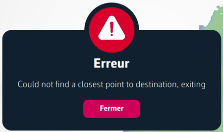
This message appears if the first isochrone cannot be calculated. It's a data problem: either the boat's data, or the target's position, or the GRIB forecast file. So you either have to wait for a new boat position, or move the target, or reload the weather (in Settings panel), or wait...
- The last boat position received from VR was more than 10 minutes ago. Please wait for a position refresh before performing a routing calculation
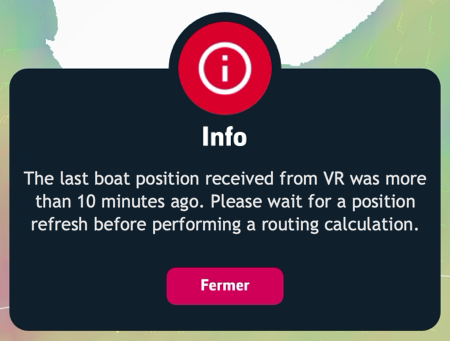
This message is usually the result of a clock offset between eSail4VR and Virtual Regatta. You need to set the time on your device to “automatic”.
- Routing calculation stopped as we reached the routing max duration.
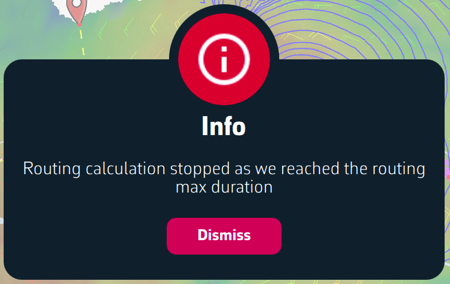
eSail4VR offers routing for up to 15 days, based on the 16-day GFS weather model. If your target is not accessible after 15 days, routing stops before reaching your destination. This is called partial routing.
- Impossible to route as it starts after the weather forecast has ended
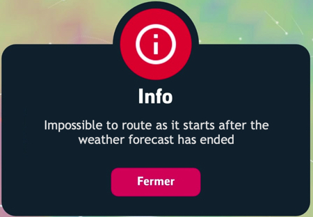
For some unknown reason the most recent weather did not load. You must refresh in settings the download before routing.
- Routing calculation stopped as we reached the end of the weather forecast
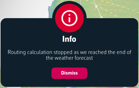
Routing stops before reaching your target because it is too far away for the duration of the forecast. Get closer to your target.
- Failed to calculate isochrone. Stopping calculation.
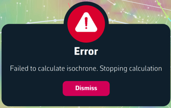
You have run into an exclusion zone (AEZ, TSS, etc.) and routing cannot be calculated. You must exit out of this zone manually in Virtual Regatta
- The routing failed as your boat is grounded
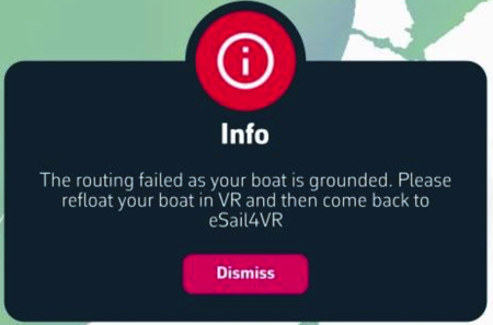
You have to refloat your boat manually in Virtual Regatta and wait for your boat be afloat before retry a new routing.
- Routing calculation stopped as we no longer progress towards the target :
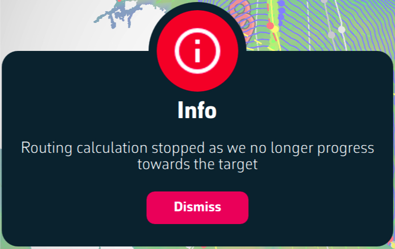
At the end of the calculation on a long routing, the isochrones are too far apart to deploy correctly. A pivot point needs to be placed to refine the end of the route with tighter isochrones.
As in 2024, the organizers of the Nation's cup have banned the sending of orders.
As far as we know, this is the only race on the calendar where orders cannot be sent.
Subscription
Permalink
Today, you can't take out a subscription directly on a Windows PC. To take out a subscription, you need to go through your smartphone (or tablet) on the App Store for iOS or macOS and on the Play Store for Android.
This subscription will then be valid on all your devices, including your PC.
PermalinkUnfortunately, this is a relatively frequent problem with the Google Play Store, where payment validation processes can fail if the bank has not taken the necessary steps. But it can also be due to connection problems with bank servers.
We have no other procedure to suggest than:
- install the app
- try to pay with a bank card
- use a prepaid card for the Google Play Store, available from supermarkets or tobacconists
- find someone you know an Apple device’s owner with which this type of malfunction almost never occurs.
Installation
💻 Desktop:
macOS:
Version 11 (Big Sur) - x86_64, x86_64h and arm64, release in November 12th, 2020. For a list of compatible devices, follow this link: Compatibility macOS Big Sur.Windows:
Version 10 (build 1809 - 10.0.17763) - x86_64, release in October 2018.
📱 Mobile:
Android:
Version 6.0 (Marshmallow) - arm64-v8, release in May 2015.iOS/iPadOS:
Version 13 - armv8 (arm64), release in September 2019.
⚠ Warning :
These operating system versions are required in order to run eSail4VR, corresponding to compatibility with our development tool.However, they do not guarantee that the application will be fully compatible with your device. Many other factors can influence performance and compatibility, such as insufficient RAM memory, a poor graphics processor, etc. Permalink
Solving a problem on a Windows PC can be complex, due to the variety of possible configurations. Here are some basic steps to check:
- Check application version
- Make sure you have the latest version of the application.
We display the version of your application in the top right-hand corner below the gear. It will be red if you have an older version. If you don't see it, your version is very old. To update your application, follow the link and press/clic "Get it from Microsoft" button.
- Make sure you have the latest version of the application.
- Check Windows version
- Your system must be Windows 10.0.17763 (version 1809) or next, 64 bits (x86_64). See the requirements in this FAQ for more details..
- Try another network
- If you're connected to home Wi-Fi, try sharing a mobile connection, or vice versa.
- If you're on a corporate network, make sure you're not behind a firewall that may prevent the loading of some data (coastline, weather).
- If you are under a VPN, disable it.
- Relaunch your PC
- Consult our Facebook Users group
- Rendez-vous atgroupe Facebook des utilisateurs de eSail4VR pour vérifier si d'autres utilisateurs rencontrent le même problème.
- Go to the bottom of this page
- Press/clic "Get it from Microsoft" button
- Download the installation file
- Run the install exec file
- Uninstall the app by placing it in the trash
- Open Finder
- Go in "User" directory[user]
- Display hidden files and folders in this directory by pressing “Command” + “Shift” + “.” (dot) simultaneously..
- Delete following folders:
English: /Users/[user]/Library/Containers/eSail4VR
French: /Utilisateurs/[user]/Bibliothèque/Containers/eSail4VR
Replace [user] by your user name on the Mac
- Quit eSail4VR
- Uninstall the application from the Windows menu "Add or remove programs.
Check that you are entering the correct login credentials. Try logging out of Virtual Regatta and logging back in to confirm your password. Then go to eSail4VR and try again.
If you still can't log in, change your password in Virtual Regatta. The easiest way to do this is to log out and ask Virtual Regatta to send you a new password by e-mail. Then try logging in with this new password.
Here's how to request a new password from the Virtual Regatta application:
- Open Virtual Regatta and tap on your avatar in the top left-hand corner. Your profile is displayed.
- Tap on “Change my password” and follow the instructions.
- Use the new password to log in to your Virtual Regatta account in eSail4VR.
If, after installation, the application loops on an hourglass, it is very likely that the time on your device is not correct.
- For Windows: go to "Date and time settings", check "Set time automatically", and then press the "Sync now" button.
- For Android: go to "Settings > Additional settings > Date and time", check "Set time automatically".
- For macOS/iOS : go to « Settings > General > Date & Time », set Time to « Automatic ».
Then restart eSail4VR.
PermalinkSettings
In Expert mode, you have the possibility to adjust the routing calculation parameters. Here are some guidelines on how to do this best. Note that you always have the possibility to reset the default values by pressing the "Reset routing parameters to default" button under the settings. We recommend using these defaults in the vast majority of cases.
Max duration (15 days)
This is the maximum duration of the routing. One may want to reduce it to understand when a route decision should be made. This can be seen during the routing calculation when the best route switches. For example, if we are sailing on the North Atlantic from Brittany to the West Indies. We can have a routing that switches from a northern route to a southern trade winds one in the middle. We calculate a routing with a 15 day max and another one with a 8 day max. We then analyse the 2 proposed routes. If the routes over the first few days are similar, there is no decision to be made immediately. If they are different from the beginning, you have to choose right away.
Sweep angle (40°- 360°)
This is the scan angle over which the algorithm will search for routes. The larger the angle, the longer the calculations, but the less chance you have of missing the best route.
As a general rule, 220° is more than enough. If we notice that our routing passes by the edge of an isochron (locations reachable in a certain time, drawn in blue), we must increase this angle. This happens most often in areas of light wind or for very fast boats like Ultims which can lengthen their route considerably to find favorable winds.
Step angle (Auto / 0°- 5° )
This is the angular increment used in the routing calculations. The smaller it is, the more accurate the calculations are, but the longer the calculation time. In auto mode, it is initially at its minimum of 1°. The router can increase it if the processor is slow and the calculations take too long.
VMG max tolerance (0° - 20°)
The VMG (Velocity Made good) is the speed the boat towards or from the direction of the wind. The best VMG angle is the angle for which this VMG is maximum. In general, it is around 40° to 45° upwind and 140° to 150° downwind. When you are offshore, far from the coast, you rarely sail beyond the angle of best VMG. For us, this can be considered very rarely as never. On the other hand, when you are close to a coast, to avoid making two tacks or two gybes in order to clear a cape, you can sail a few degrees beyond the angle of best VMG. This will avoid 2 penalties and a loss of energy. To conclude, we always do a first routing with a tolerance of 0° and we only put a tolerance higher than 0° to avoid 2 manoeuvres when clearing a cape.
Isochronous < 2, 6, 12, 24, 48, 120 hours
This is the time step between 2 isochrons. This time step increases as you move further out in time because the weather conditions will change by then and it is useless to look for too much precision. Near the coast, it can be interesting to decrease the time step of the first isochrones to stick to the coast. The shorter the time step, the longer the calculations.
Have fun changing these parameters to get the best routing. Remember that we spent a lot of time optimizing the default values. These are the best in the vast majority of cases. When in doubt, don't hesitate to press the "Reset routing parameters to default" button.
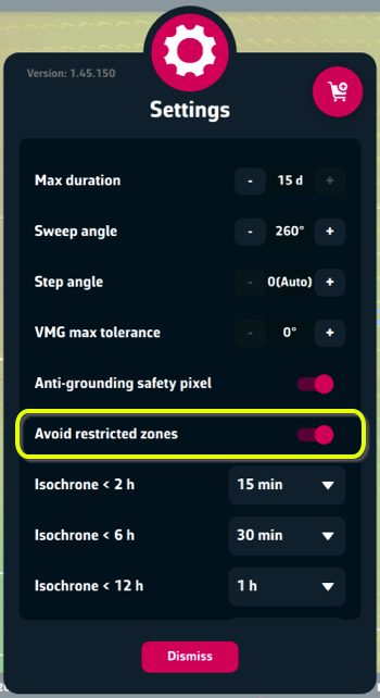
PermalinkVirtual Regatta provides the coastline to within 1 pixel. This allows us to reproduce the coastline exactly and prevent routing from approaching the coast to within 1 pixel. This is particularly useful when routing has to navigate through narrow passages between islands.
![]()
Caution: this option does not work for restricted zones.
PermalinkYou can send your orders in 4 different modes, plus Auto mode. This one will select the mode considered best according to the conditions encountered. For example, “Waypoint” mode near a coastline or exclusion zone.
- Wind: the angle between the boat and the wind is constant between 2 orders. In VR, the padlock is closed. This is the preferred mode if you are offshore.
- Compass: the heading of the boat is constant between 2 orders. In VR, the padlock is open. This should be used if you are offshore in light variable winds.
- Mixed: if your boat is sailing upwind or downwind, the order will be sent using the Wind mode, otherwise, the Compass mode is used.
- Waypoints: the boat will sail from waypoint to waypoint using their coordinates. This is the preferred mode when close to shore.
Read also "How to read a line from the order editor" in this FAQ.Permalink
Depending on your VR options you can use a maximum number of orders.
- no option: 2 orders
- Full pack: 9 orders
- VIP: 15 orders
It is key to use these limited set of orders wisely.
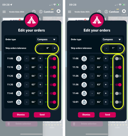
To optimize the sending, you can skip orders if the previous one was close to the current one. The "Skip order tolerance" parameter allows you to decide how close should be these orders to skip them.
In practice, if you want to send your orders for a long time, like during night, increase the tolerance.
Display
If you don't see your boat data, it's most likely that the time on your device is not correct.
- For Windows: go to "Date and time settings", check "Set time automatically", and then press the "Sync now" button.
- For Android: go to "Settings > Additional settings > Date and time", check "Set time automatically".
- For macOS/iOS: go to "Settings > General > Date & Time", set time to "Automatic".
Then restart eSail4VR.
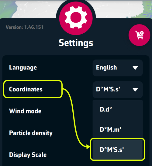
You have to set the coordinates in Settings in degrees, minutes and seconds, to match those of Virtual Regatta.
Please note: don't be fooled by the white lines symbolizing the route: they're only there to look pretty, and they're not the same in the 2 applications, as the VR one isn't sent to us.
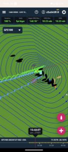
To compare your position, simply tap/click on your boat in both applications and read the respective coordinates as shown below:
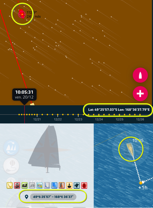
The data in the Virtual Regatta game are exactly those displayed in our right-hand column (or upper for smartphones), as we are connected to their server in real time. It's this initial data that's taken into account for routing calculations. To compare them, simply tap on the red “boat” button to center it on the exact time and compare the information at your position with that of VR. The only (minor) discrepancies are due to rounding.
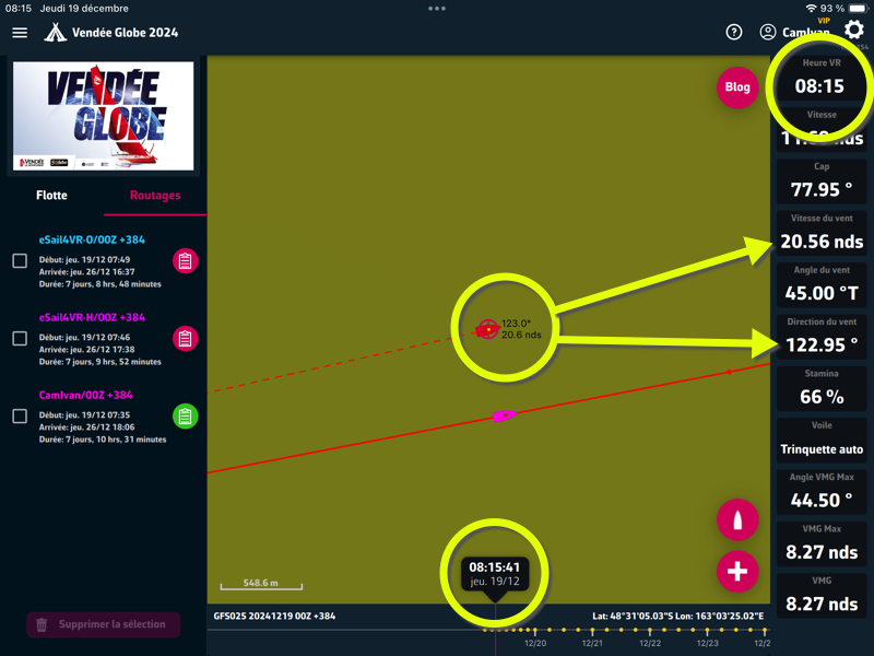
Target colors warns on such area it is localized:
- Red = OK (on open sea)
- Black = grounded
- Green = within 1 pixel of the shoreline (*)
- Yellow= in a restricted zone
- White = within EAZ
(*) Read in this FAQ "Anti-grounding safety pixel: what does it mean?"Permalink
In two words: be patient!
When you press the + button in the bottom right-hand corner of the screen, the application searches the Internet for a certain amount of information to make sure that all its data is up to date. If these requests are slow, then you'll see an hourglass.
Requests can be slow for 2 main reasons:
- a large number of players are loading weather GRIB files at the same time
- your Internet connection is slow
You don't have to do anything, just be patient. It can take up to 30 seconds.
Tap on the red [+] button opens the window for creating targets and starting routing to them.
If you have already performed a routing, and the isochrones are displayed on the chart, moving the chart will display the yellow line allowing you to position a pivot point to modify the course of your routing. During this operation, the routing window will not allow you to create a new target.
To ensure that routing is done with recent data, the send button remains active only for 10 minutes after the routing has been calculated.
Calculate a new routing and everything will be back to normal.
On each isochrone, a blue dot indicates the point closest to the finish on that isochrone. This is very useful to place a pivot point wisely. In this case, we'll give priority to ranking up to this isochrone.
In example, if the best routing is very far from the direct route, it is recommended to make a second routing with a pivot point passing through one of these blue points. If the second routing is very close in time to the first, it's often a good idea to follow it.
Read in the blog Ces isochrones...
PermalinkeSail4VR systematically displays all followed/friend boats sent to it by Virtual Regatta. There is no limitation.
However, it may happen that you don't see them in the “Fleet” pane. There may be several reasons for this:
- The time on your device is not exactly the same as VR, but in this case you may not be receiving your position and/or data from your boat. You need to set the time on your device to automatic and relaunch the application.
- The network connection to the VR server is not working, or is working incorrectly. Check by changing network, for example from Wi-Fi to cellular. Otherwise, just wait.
- The network connection to the VR server doesn't work, but your network works perfectly. Try reconnecting to your account by re-entering your login details..
In any case, it is useless to send us a message on support, the cause cannot come from eSail4VR.Permalink
Routing
You probably registered just after the race opened.
You've tried routing, but the weather forecast grib file associated with the race has not yet been created on our servers; an empty grib file is loaded and crashes the application.
Wait for the next weather file update and everything will be back to normal.
PermalinkIt depends on what type of regatta you race and where you are in the race.
There is one universal principal though : the target should be as much as possible "visible" from the boat position with as little land as possible between them.
This means that you should not put a target just behind an island, behind a cape, at the far end of a bay...
PermalinkThe strategy depends on your current position. However, there is one basic principle: the target should be 7 to 15 days' sailing ahead of your boat and as “visible” as possible from the boat's position, with as less shoreline as possible in between. In other words, avoid placing a target just behind an island, a cape or at the bottom of a bay.
For the start of the Vendée Globe, here are a few useful tips:
- Descending the North Atlantic:
- At the start, you generally encounter one or more lows. You need to take advantage of the wind shifts by sailing more to the west ahead of the low-pressure area, where the winds are from the south-west, and then south on the way out, when the winds shift to the north-west. Occasionally, you may encounter anticyclonic conditions with northeasterly winds, in which case you'll have to sail downwind towards the Canaries.
You then sail wind a beam in the trade winds of the northern hemisphere. You'll need to choose where to pass the doldrums, which are generally quite active at this time of year, and lie around N7°. In general, winning routes cross the doldrums and then the equator between W25° and W30°, and even up to W35°. Be careful not to have to tack in the southern hemisphere trade winds (SE'ly winds) if you go too far west..
- At the start, you generally encounter one or more lows. You need to take advantage of the wind shifts by sailing more to the west ahead of the low-pressure area, where the winds are from the south-west, and then south on the way out, when the winds shift to the north-west. Occasionally, you may encounter anticyclonic conditions with northeasterly winds, in which case you'll have to sail downwind towards the Canaries.
- Passage of the Saint Helena High :
- After the Equator, pass to the west of the St. Helena High to “catch” favorable downwind conditions off Argentina.
Keep an eye on the lows forming behind the Andes, which may enable you to take a shortcut and avoid making a long “ladle” along South America.
- After the Equator, pass to the west of the St. Helena High to “catch” favorable downwind conditions off Argentina.
- Bypassing Antarctica :
- When you enter the Indian Ocean, sail around Antarctica, following the Antarctic Exclusion Zone (AEZ), to stay within the strong winds of the roaring forties and howling fifties.
Most of the time, stick to the AEZ to minimize the distance you have to cover.
- When you enter the Indian Ocean, sail around Antarctica, following the Antarctic Exclusion Zone (AEZ), to stay within the strong winds of the roaring forties and howling fifties.
- South Atlantic ascent:
- After Cape Horn, it’s a tricky. Either you go up along the coast of Brazil, or you go further offshore. Several groups usually form, as the weather forecasts are not stable. You'll have to make a choice.
- Crossing the Equator and approaching the finish :
- The Doldrums are generally less active on the way back and shouldn't be a problem. Most of the time, you'll have to round the Azores High, leaving it to the east on your right. Once you're sailing in downwind conditions, it's a straight shot to the finish..
Departure advice
Initially, place your target at the equator, between W25° and W35°. Try several different targets to find the best trajectory. Then adjust your target every 3 to 4 days, following the outline of the “winning” route. Make sure your target is always about ten days ahead of your boat to optimize visibility and facilitate navigation.
Read in our blog Where to place the routing target
PermalinkYes, the application calculates these penalties as well as the Stamina and takes them into account in routing. Read this article about stamina in our blog.
PermalinkYes, the boundaries of Cetacean and Biodiversity Protection Zones, as well as Traffic Separation Devices, are marked in red.
Routing takes these exclusion zones into account. Red also "How do I route with restricted zones?" in this FAQ.
Yes, the Arctic/Antarctic exclusion zones are marked in white.
The routing takes these exclusion zones into account. Please note that they may be modified during a race if the actual race committee changes them.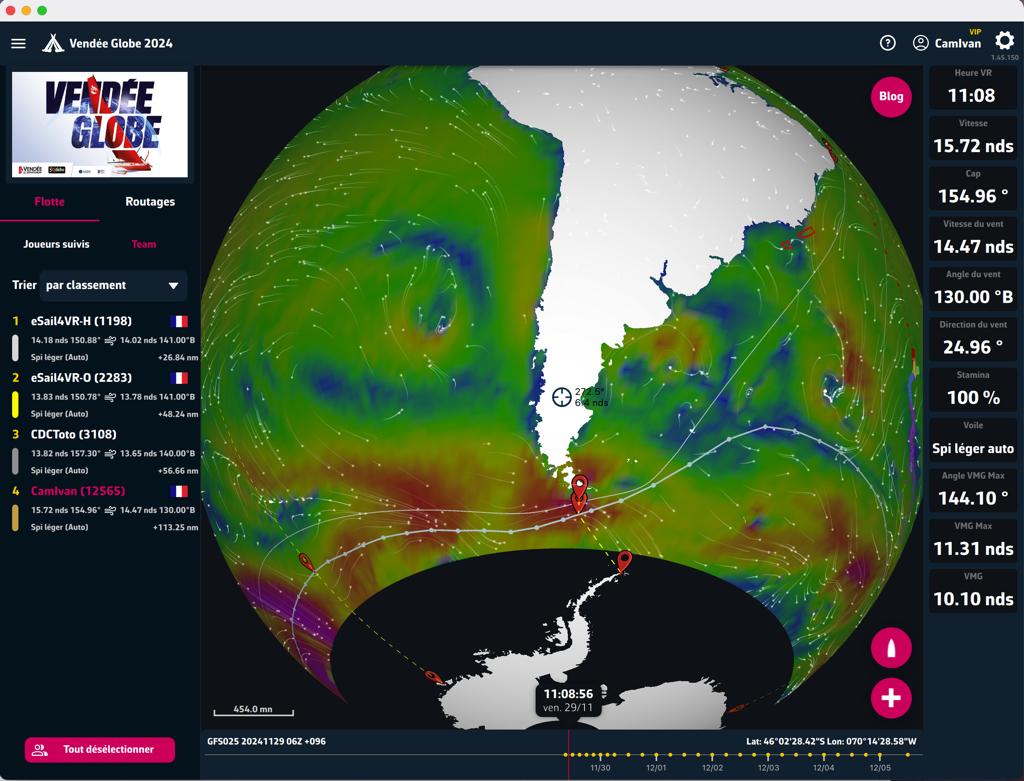
Routing with restricted zones presents new challenges well known to offshore sailing racers, and in particular those who have raced the Fastnet.
In Virtual Regatta, as for sailing racing commities, several restriction zones are implemented:
- TSS: Traffic Separation Scheme
- BPZ: Biodiversity Protection Zone
- CPZ: Special Cetacean Protection Zone
- AEZ: Arctic / Antarctic Exclusion Zone
You might think that exclusion zones are simply islands. This is not quite the case, however, because unlike inland areas, the winds are not slowed by the restricted zones, and optimal routes often pass through them.
What's more, it's sometimes necessary to tack between these zones, and routing algorithms have a hard time finding optimal routes.
If there are many restricted zones on the direct route, professional routers recommend first to perform a routing without the restricted zone, to understand what the optimal route would be without it, and then activate the restricted zones to finalize the routing study. We often use pivot points or intermediate targets in the corners of these zones.
We have therefore added the “Avoid retricted zones” parameter to the routing settings so that you can apply this method. But be aware: it is imperative to avoid sending orders in Wind mode. Only Compass or, even better, Waypoint. Search for “order” or “mode” in this FAQ.
This setting is enabled by default, and can only be changed with the eSail4VR Premium subscription.
TWS : True Wind Speed - Speed of the real wind
TWD : True Wind Direction - Direction of the real wind
TWA : True Wind Angle - Angle of real wind related to the boat
SOG : Speed Over Ground - Boat speed over the ground
COG : Course Over Ground - Course of the boat over the ground
Stamina : Skipper's energy
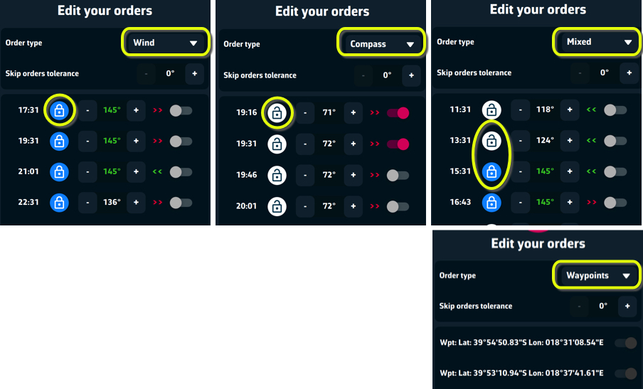
Wind Mode
- the padlock is closed, blue in color, we're in wind mode.
- the 145° angle is the wind angle. The color of the numbers is green, we're close to the best downwind angle (VMG). Otherwise, the color is white.
- double-arrows are red, we receive the wind from the left. We're sailing on the port side.
- double-arrows are green, we receive the wind from the right. We're sailing on the starboard side.
- switch is red ( enabled ) = command will be sent.
- switch is grey (disabled) = order will be cancelled.
Compass Mode
- the padlock is open, white in color, we are in compass mode.
- the 71° angle shows the course to follow.
- double-arrows are red, we receive the wind from the left. We're sailing on the port side.
- double-arrows are green, we receive the wind from the right. We're sailing on the starboard side.
- switch is red ( enabled ) = command will be sent.
- switch is grey (disabled) = order will be cancelled.
Mixed Mode
- the padlock can be open or closed. Open: the angle shows the course. Closed: the angle is that of the wind; if in green, it's the VMG.
- double-arrows are red, we receive the wind from the left. We're sailing on the port side.
- double-arrows are green, we receive the wind from the right. We're sailing on the starboard side.
- switch is red ( enabled ) = command will be sent.
- switch is grey (disabled) = order will be cancelled.
In this mode, routing selects the best compromise according to the conditions encountered.
Waypoints Mode
- The routing is sent as a series of waypoints that cannot be modified. This is the best choice for tricky passages, along the coast or close to exclusion zones.
NOTE:
Routing has limitations. If the wind is weak and highly variable, it's very difficult to send coherent orders. Wind mode is hazardous, because if the timing isn't right (wind shifts earlier or later than predicted), you run the risk of being blown off course. Compass mode ensures that you're heading in the right direction, but it won't be optimal (it's the mode chosen by Auto mode). The best solution, though not easy to implement, is to send your orders in Wind mode and then go into VR to observe the predicted route and edit it manually.
PermalinkFirst of all, check if the Expert Mode option is enabled.
If you've received a message confirming that your programming has been received by Virtual Regatta, it should be taken into account by the game engine. Wait a little and reload the game page to confirm that everything is OK.
Then zoom in sufficiently on your boat to check that your programming points appear correctly.
Depending on your VR status:
- Without Full Pack or VIP: 2 programming points
- Full Pack without VIP: 9 programming points
- VIP: 15 programming points
You need to zoom in enough on your boat to see your programming points, which you'll also find in the routing panel. Before you reach the last programming point, you need to have sent a new routing so that your boat doesn't drift away, as it does in VR if you're in Wind mode (padlock closed).
In the worst case, if you're in Wind mode (padlock closed) and you're not sure of sending a new routing in time, you can select the last programming point in VR and open the padlock (compass mode), so the boat will follow the course of the last point.
You can also extend your programming in time: read “Skip order tolerance” in this FAQ.Permalink
If the routing deviates too far from the direct route, the result is a “stepped” routing. The routing ends up on the edge of the isochrone. To avoid this, increase the sweep angle in the routing parameters. The default setting is 220°. If your device is fast enough, set it to 360° and you'll never have to wonder again.
If you haven't taken the Premium option, add an intermediate target. You can place it on the stepped routing, towards its middle.
With a search angle of 220°, you've got stairs.
With a 360° search angle, the stairs have disappeared.
Start by selecting a routing in the routing pane. The blue isochron lines should be displayed.
- On a "touch" device like a phone or tablet. When the screen center is on an isochron point, you will see a yellow route from the boat to the center of the screen.
The picked pivot point will be this point at the center of the screen.
Press the + button, choose your target and press the routing button. - On a device with a mouse like a PC or a Mac.
When the mouse is on an isochron point, you will see a yellow route from the boat towards the mouse.
The picked pivot point will be this point at your mouse indicator.
Right click on your mouse, choose your target and press the routing button.
A pivot point is a point where the boat is forced to sail through.
They can be used in 2 different ways.
- To do what if scenarios. What would be the routing if I force to sail through this point? Do I loose much time? Is it safer?
For example, say it takes 5 days to sail towards our target. If the outing calculation finds a fastest route going through a couple of low wind areas and with a pivot point a route 5 minutes longer but with no "danger zones", I would rather sail the second route found with a pivot point. - To continue the routing after a waypoint in VR
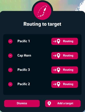
Yes, it's very useful for anticipating their route and controlling them.
On a mobile device such as a smartphone or tablet:
- Select a competitor by short-pressing on the map or in the list of followed players in the fleet tab (the map automatically centers on the boat and its name appears).- Long press on the boat, the Routing to target menu appears.
- Press the Routing button opposite the target you've chosen
On a computer with a mouse or a trackpad, such as a PC or Mac:
- Select a competitor by clicking on its boat on the map or in the Fleet tab. The boat's name should appear on the map.- Point your mouse at the selected competitor's boat. Right-click, the Routing to target menu appears, press the Routing button opposite the chosen target.Permalink
Start must be made in the VR interface, not with eSail4VR.
What you have to do:
- Perform routing in eSail4VR and choose departure time
- Manually set the first heading in the VR interface
- At the time selected "Start an attempt" in VR
- Once the first position has been received in eSail4VR, redo the routing and send it.
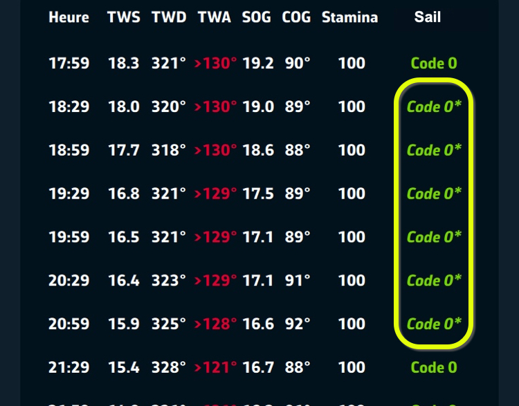
Q1: What happens when a sail is changed in automatic mode?
When changing from one sail to another, there is a wind speed threshold (TWS) which determines when the new sail becomes faster than the old one. At this threshold (TWSc), the boat reaches a reference speed (BSc).
Q2: Why doesn't the sail change immediately when the new one is faster?
To avoid unwanted sail changes, the system only switches to the new sail when the boat's speed exceeds the reference speed by a factor of 1.4% (BSc x 1.014). This factor is called the “overlap factor”.
Q3: What is the “boost effect”?
The boost effect occurs between the moment when the boat's speed reaches the reference speed and when it exceeds the recovery factor. During this range, although the new sail is faster, the boat is still moving forward with the old sail, but at the speed of the new one. This creates a temporary performance boost.
Q4: Why is it beneficial to sail in auto sail mode?
In auto sail mode, the boost effect is applied, giving the boat a temporary advantage. In manual mode, this effect is not present, making automatic mode more advantageous for maximizing speed. However, in some situations, it may be advisable to temporarily deactivate the Auto-sail mode in Virtual Regatta.
Q5: How can you tell if you're about to go into boost mode?
A star* is displayed at the right of the sail in the routing table..
Q6: What to do if you see this star*?
As a precaution, to avoid untimely sail changes, you can decrease or increase the wind angle (TWA) to exit this zone. For example, if the routing table indicates: TWA 110° Code Zero *, you can change the order to 108°.
If the Routing table shows a succession of sails with this asterisk on a course, it may be advisable to temporarily disable the Auto-sail mode in Virtual Regatta to avoid the risk of multiple sail changes due to possible wind variations. Read blog post about AEZ.
Permalink
Weather
The calculation of weather forecasts takes time!
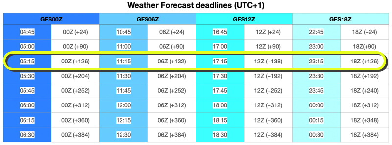
Virtual Regatta uses GFS 0.25° weather forecasts provided by NOAA, the weather service of the United States. They are, of course, the same forecasts we uses.
These forecasts are calculated 4 times a day and the outputs are identified by the time of the beginning of the calculation in UTC time, also called Z. So we have the outputs of 00Z, 06Z, 12Z and 18Z.
For each calculation, the first 24 hours of forecast are available after about 3h40 of calculation, and delivered in eSail4VR few minutes after, about 03h45 UTC for the 00Z model. That makes 4h45 in winter time and 05h45 in summer time for France. Then, (+90) indicates that the first 90 forecasts hours are available, and so on.
Here is a summary table where you will find the update times of the weather forecasts (UTC+1):
WARNING:
The NOAA is sometimes late and in this case the files are not updated. It doesn't matter because they are not updated in the game as well. What matters is that we are synchronized with the game. The NOAA delays can be due to the production of the model or its distribution.
You can check how the PRODUCTION is going by following this link.
You can check how the DISTRIBUTION is going by following this link.
Now, at what time to do the routings?
The best compromise seems to be (European Central Timezone):
- Winter time (UTC+1): at 05h15 or at your alarm clock, 11h15, 17h15 and 23h15.
- Summer time (UTC+2) : at 06h15 or at your alarm clock, 12h15, 18h15 and 00h15.
⚠️ Possible delays in updating forecasts
Nothing to be done! The delay probably comes from NOAA and will be resolved on its own.
From time to time, NOAA may experience delays in the production or distribution of its GRIB files. This means that in-game weather forecasts will not be updated until NOAA catches up. The important thing is that our application remains synchronized with VR, and this is most likely the case. You can check the PRODUCTION status here and DISTRIBUTION status here.
We understand that this can be frustrating, and we sometimes receive messages from impatient players, such as “1:36pm and still no weather update beyond 108 hours !!!!!!”. We invite you to contact us if you think you've identified a problem, but please be aware that adding lots of exclamation marks won't speed up its resolution. 😊.
In very rare cases, the problem may be on our side. Rest assured that we will do our utmost to resolve any anomaly quickly when it occurs.
PermalinkLet's try to understand the information given by eSail4VR and Virtual Regatta (VR).
In eSail4VR
A GRIB file is identified by an identifier such as:
GFS025 20241209 12Z +384
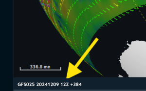
That means :
1. GFS025: The weather model used is GFS, with a resolution 0.25°.
2. 20241209: The model initialization date is Decembre the 9th, 2024.
3. 12Z: The last available run (simulation) is that at 12h UTC.
4. +384: This file includes 384 hours of weather forecasts from this run.
However, this GRIB file is actually made up of several time steps from different runs. In the following example, we have the following time steps:
- 20241209.06.009: wind for the 9th hour of the 06Z run
- 20241209.06.012: wind for the 12th hour of the 06Z run
- 20241209.12.009: wind for the 9th hour of the 12Z run
- 20241209.12.012: wind for the 12th hour of the 12Z run
- ...
- 20241209.12.384: wind for the 384th hour of the 12Z run
But how to calculate the boat's wind at 19h52 UTC (20:52 local time in Paris)? ⏱️
We use a linear interpolation between the 2 time steps closest to 19:52 UTC in our grib file.
- 20241209.06.012 : it is the 12th hour of the 06Z run, so the wind forecast at 12 + 6 = 18h00 UTC
- 20241209.12.009: it is the 9th hour of the 12Z run, so the wind forecast at 9 + 12 = 21h00 UTC
The length of each time step depends on the current time:
At 19h52 UTC, we are 112 minutes after 18h00 and 68 minutes before 21h00.
- the weight of time step 20241209.06.012 is therefore 68
- the weight of time step 20241209.06.009 is therefore 112/180
In short, at that time, the wind used in eSail4VR is an interpolation between:
- 38 % of the data from the 06Z run (time step 20241209.06.012)
- 62 % of the data from the 12Z run (time step 20241209.12.009)
🌊 In Virtual Regatta
Virtual Regatta's interface shows this interpolation graphically:
[caption id="attachment_34307" align="alignnone" width="350"]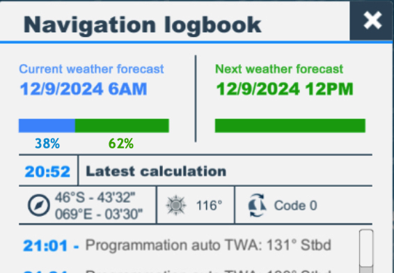 Screenshot of VR where we have added the percentages of each time step[/caption]
It is 8:52pm (French local time), so 19h52 UTC.
- The blue section of the left-hand gauge represents the weight of the 06Z run, equal to 38 %
- The green section of the left-hand gauge represents the weight of the 12Z run, equal to 62 %
- The gauge on the right is full green, meaning that from 21h00 UTC (10pm local), the boat's wind will come from interpolations between time steps all issued from the 12Z run.
N.B. Percentages numbers are not displayed in Virtual Regatta, only gauges.
✅ Conclusion
Although the information displayed is different, eSail4VR and Virtual Regatta use strictly the same data and the same interpolation logic to calculate winds from GRIB files. These interpolations make it possible to calculate weather conditions at any time, by combining data from the various available runs.
Permalink